Integral management
of territorial information

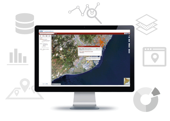
GIS Corporate is a geographic information management system that provides tools to analyse and process territory-related data.
It is completely adaptable and scalable, covering all territorial needs. It allows to cross geographic information between different departments and take informed decisions.
It allows to manage and evaluate the information of a territory, obtaining a global, unified and updated view of the situation
The Corporate GIS coordinates and integrates all territorial information of different departments of an entity, providing tools and benefits to the organization

UNIFIED
GEOGRAPHIC DATABASE
SECURIZED
GEOSERVICE BUS

INTERNET/INTRANET

CONFIGURABLE
CARTOGRAPHIC VIEWER

METADATA MANAGEMENT
(INSPIRE)

ACCESS ACCORDING ROLE AND PROFILE

CENTRALIZED
PUBLICATION

BASED ON OPEN SOURCE TECHNOLOGIES
Harmonizes technology and implements a new organizational model

The corporate platform allows to avoid the dispersion and duplication of geographic information, keeping it unified, but distributed among departments.
Corporate GIS optimizes development costs, integrating different work needs and operations of different departments of a company or administration.
Implementation of a corporate geographic information system implies a significant organizational change:
- Optimizes current geographic information management processes
- Development of GIS tools and technologies shared between departments of the organisation
- Access to contents according to profiles and roles
- Avoids duplicities
- Centralized publication
Integrates information and administrative tools
The system, which has a powerful geoservice bus, unifies all geographic information of different departments and provides secure access to information, following the OGC international standards.
GIS Corporate can be integrated with other technologies and customized according to each client’s needs.
Cost savings: own product

Other geographic information systems work with components subject to commercial licenses (ex: web viewer ESRI/INTERGRAPH). GIS Corporate is based on open source components that allow great flexibility, scalability and have configurable tools without extra costs; Corporate GIS does not rely on commercial licenses.
Case study
CLIENT
Generalitat de Catalunya

SECTOR/INDUSTRY
Public administration – Corporate environments
Corporate GIS, the solution of Generalitat de Catalunya for the management of territorial information
OBJECTIVES/CHALLENGES
Geographical information of the different departments of Generalitat
de Catalunya was dispersed, non-standardized and with very high
licensing costs.
DESCRIPCTION
Geoservices-oriented GIS platform that includes a portal with a powerful
cartographic viewer and tools to manage and share geographical
information between departments.
PRIZES
In 2017 Corporate GIS was awarded the first Alfons Ortuño Prize, awarded by the School of Public Administration of Catalonia.
Prize in sector policies and finalist services
